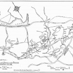
Bill sent me the following map. You can see a larger version of it by clicking on it. He said:
Here is a Quebec Highways Dept map of the new Hwy 5 extension to Wakefield with the NCC trails superimposed. It seems to imply minimal impact on park users, due to the interchange at Cross Loop, and the rerouting of Hwy 308 to the interchange near the Giant Tiger store; presumably the Wakefield parking lot would be entered from that rerouted highway. Of course, construction may yield interesting times.


I hope the impacts is low. It’d be a real crime otherwise!
Small correction needed..it is the 366 from Masham and not the 308 that is being diverted to the top of Valley Drive at Wakefiled by the GT. As the 366 must stay open for traffic, hopefully, park access from P17 will always be possible.
Plans also include for the trail to continue to underpass the four lanes of the A5 and the two lanes of the 366 just west of the Wakefiled Mill.
P17 will move about 100m west from present location. Additional bike lanes/trails planned for exchange under A5 to reach P17 from Valley Drive.
The unofficial entrance at Brown Lake/Road calls to be closed for good.
There are some real issues with the planned highway.
First of all, closing access to Brown Lake Road is a real loss to Wakefield as people like to swim there in the summer.
Next, there will be 8 lanes of traffic side-by-side as they have the 4 lanes of the new road, 2 lanes of 366 and 2 lanes of the old road! Is this really necessary?
Hi,
Can someone tell me how to get to P17 (Wakefield) from downtown Ottawa by car?
I want to get to trail 72 to go snowshoeing.
Any help would be appreciated. Thanks.