
If you stand at the Champlain Lookout you can see two things. One is a road stretching straight away westward toward the Ottawa River. Where that road meets the bottom of the cliffs below you is called Young’s Corner. Another thing you can see looking northwest along the face of the escarpment, is evidence of a rock-fall. It turns out this is just beyond Western Lodge. In the cold morning of April 1957 that rock-fall pretty much shook the residents around Young’s Corner right out of their beds.
In 1998 Don Hogarth wrote an article explaining why the Eardley Escarpment is falling down at this particular place. It turns out that about a billion years ago there was almost a volcanic explosion here. It smashed the older rock before new molten rock squirted into the cracks. The new rock was slightly water soluable and on that Spring morning fifty-odd years ago frost in the cracks was enough to bust the mountainside loose. Within a very short time this newly exposed rock had been cultivated by its natural fauna—rock climbers.
Don Hogarth has kindly given me permission to reproduce his article as it first appeared in The Ottawa Field Naturalist’s Club periodical Trail & Landscape April-June 1998. Here it is:
Rumblings in the Park
An explosion and related rock slide near
Champlain Lookout,a billion years apart.
Donald Hogarth
Department of Geology
University of Ottawa
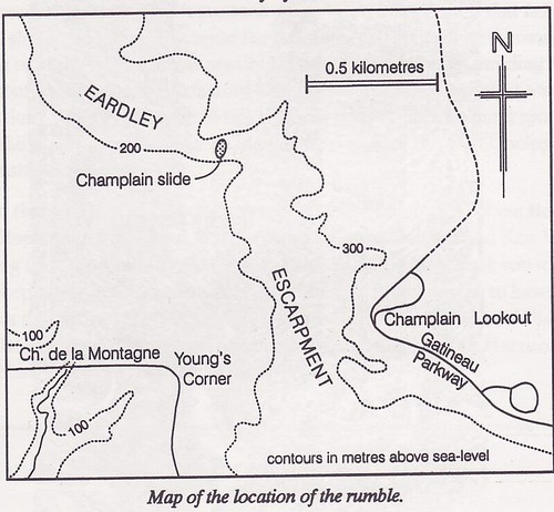
Early one day, probably in April, 1957, residents of Young’s Corner beneath Champlain Lookout were awakened abruptly by a violent crash from the north and an accompanying earth tremor beneath them. Part of the Eardley Escarpment (see map) had come tumbling down and its face had taken on a new form. The timing of this event, which we will call the Champlain slide, is impossible to pinpoint, but it definitely postdates mid-August 1956, when the writer first explored the scarp, and it certainly predates late-April 1962, during his second visit, when large fresh blocks barred the way. Inquiry from the residents below, off Chemin de la Montagne, produced some additional information. Oh yes, they remembered it well. And who could forget being rudely shaken from his or her peaceful slumber at 4 a.m. one frosty spring morning “four or five years back.” Further precision is virtually impossible. Dr. David Forsyth, a seismologist with the Geological Survey of Canada, states that, with a minor tremor like this, by the time the shock had reached the Ottawa seismographs, it would be irretrievably intermingled with a myriad of other small shocks (including the effects of construction and traffic). The Gatineau earthquake would be hopelessly lost in the background.
Why did these rlocks choose this specific site to fail and this particular time to break loose? To answer these questions we must review a few scientific truths and go back many years in time.
Rocks of the Champlain slide and surroundings belong to the Wakefield batholith, an irregular body composed of igneous rock, that was emplaced as a molten mass at great depth, some 1,150 million years ago, and is now exposed over 110 square miles (or 70,000 acres or 28,000 hectares) of rolling countryside and much of Gatineau Park. In the immediate area, the predominant rock is syenite (like granite but lacking quartz), and less abundant granite pegmatite (a coarsegrained quartz-feldspar rock) and aplite (a rock of the same composition, but in sand-sized grains). All three are very hard and notably brittle.
Let us now move on 125 million years (that is to 1,025 million years before present) to a time of crustal relaxation or perhaps even tensional stress, when solidified syenite was intruded by molten carbonatite (a liquefied rock of calcite-dolomite composition). As the carbonatite moved upwards, gases disassociated from the melt and the local pressure built up to a level where it exceeded the strength of the rock, which was then rent in violent explosion. At that point the freed gases escaped through newly formed fractures and the pressure was suddenly released. The liquid, which had now lost its melt -enhancing watery fluid, quickly solidified into a calcite-dolomite rock. In effect, the fractures were sealed with carbonatite. Thus an explosive breccia came into being here, a rock composed of coloured blocks and fragments of syenite, pegmatite and aplite, cemented with sheet-white carbonatite (see figure).
In the illustration, syenite fragments (clasts) are shown disorientated, one from the other. This is to be expected after a violent explosion, where the strata would be fragmented, disrupted and thoroughly mixed. One clast would be rotated one way, its neighbour another, resulting in a random orientation. This feature is shown by the alignment of dark minerals in the clasts (in the illustration). When the clasts came to rest they were glued in place by white carbonatite (unpattemed). In their new environment, the still-hot clasts reacted with the cement to produce a narrow rind (up to one centimeter thick) of blue amphibole and brown mica.
The Champlain slide exposes one of many explosive breccias in the southern part of the Wakefield Batholith, which include the floor ofPortune Lake and the benchmark point on NCC trail 36 at Hope Bay (Meech Lake). Such breccias in Gatineau Park are not new discoveries. They were described as sedimentary structures conglomerates by J. B. Mawdsley in 1930, but were re-interpreted, with a model similar to that outlined here, by R. Beland in 1952 (see “further reading and reference” at end of this paper). What is special about the rock at Champlain slide, is it’s three-dimensional aspect. Here we see a slice through the throat of the breccia pipe.
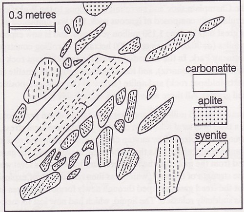
The breccia at Champlain slide, after a 1962 sketch of the side of one of the dislodged blocks. The contact between carbonatite and syenite (or aplite) is marked by a narrow reaction zone of mica and amphibo1e, omitted for simplicity. Patterns on syenite clasts indicate trends of dark minerals. Part of an aplite clast is shown near the top of the illustration, but granite pegmatite clasts do not appear in this restricted view.
Returning to geological events, the next chapter of note is the widespread initiation of brittle fracturing which took place throughout the Outaouais, 450 million years ago, or perhaps later. Along these fractures, the Ottawa Valley slice (which underlies the present Ottawa River and the municipalities of Ottawa, Gatineau, Hull and Aylmer) was enabled to subside several hundred metres, activated by sheer gravity, and resulting in the proto-Eardley Escarpment on its northern side. Por our purposes, this escarpment is important because it is defined by a steep face along which rocks can fail in rock slides. Today, the escarpment descends steeply, about 700 feet (200 metres), to the Ottawa River plain below.
Since the appearance of the Eardley Escarpment, the area has remained relatively stable. It is true that the Valley transects an active seismic wne at Ottawa, but shocks are minor and the turbulence associated with igneous activity is long since past. For the most part, after the Ordovician inundation (about 450 million years ago), the area has remained above sea level and exposed to the elements. Even during the brief post -glacial marine incursion (10,000 years ago) the site of the Champlain slide was 45 metres above the icy waters of the Champlain Sea. However, it was this very continental stability that, in the end, resulted in rock failure and land slide. The relatively high block horst of the Park was exposed to several hundred million years of continuous and unrelenting erosion. The softer and more-soluble carbonatite (with respect to syenite) was preferentially attacked. Over the years, water percolated through the somewhat permeable carbonatite and openings were enlarged by further solution. The rock became water saturated. Rock failure was probably triggered by springtime freeze-and-thaw. And then the roof came crashing down.
Today, the wall behind the slide is smooth, drab-gray and monotonous. Formerly it was almost white, interrupted by a narrow dyke of pink pegmatite running the length of the subvertical face, and by a layer of pink aplite at the top. The face showed a few carbonatite-sealed fractures but these were most evident in the huge blocks of dislodged rock at its base. Failure seems to have been most common along the contact of carbonatite and syenite or aplite, especially where these rocks had reacted to produce a coating of fine-grained amber mica or blue amphibole asbestos.
It is regrettable that weathering has obscured this spectacular geological site, but what nature has hidden in one place it will reveal in another. With lateral recession of the escarpment more carbonatites are bound to appear. But this process is time consuming, and few of us can afford to wait one or two hundred years for the next exposure.
Further reading and reference
- Baird, D. M. 1972, editor, Geology of the National Capital area. 24th International Geological Congress. Guidebook to Excursions B-23 to B-27. 32 pp.
- Beland, R. 1952 Le pseud<xonglom6rat du Lac Meach. Le Naturaliste Canadien 78:361-366.
- Hogarth, D. D. 1970. Geology of the southern part of Gatineau Park, National Capital region. Geological Survey of Canada, Paper 70-20. 8 pp., plus Map 7-1970.
- Mawdsley, J. B. 1930. The Meach Lake Conglomerate. Transactions of the Royal Society of Canada 24:99-118
 The cards that GuideGatineau has begun distributing to promote the website are considered to be highly environmentally responsible due to the fact that the paper used is 100% recycled and is produced using energy from biofuels plus the ink is vegetable based.
neat… interesting to know.
what brought about the roads up in the gatineaus though? I heard there was a farm up there at one point and an apple orchard or such?
What about all the trails? who made them? how long have they been around for?
Actually the NCC is working on a 3rd edition of their Gatineau Park Chronicle and it is going to be focused on roads, paths and trails and how they got there. There were indeed farmers in the hills and Ridge Road was actually a farm road. The first settlers arrived in the 1820s to 1840s but the higher hilltop farms didn’t get taken up until the 1860s and were so though to make a living on that most families moved “off the mountain” after one generation.
You can find the first and second editions of the Chronicle at these links.
http://j.mp/9OTrQg
http://j.mp/16pdOd