
For an outsider listening to people talking about skiing in Gatineau Park the most frequently mentioned places to ski are perhaps the parkways, followed by Ridge Road, followed by Burma Road.
Grab your official NCC trail map; I defy you to locate Burma Road anywhere on there.
What’s more, somewhere named Burma hardly sounds like a place that snow would accumulate.
This is where GuideGatineau earns its name and explains to you where the heck Burma Road is, how it earned the name Burma and why it’s now called Huron trail even though it doesn’t even go to Huron Shelter.
To start with, the trail that isn’t marked Burma or Huron on the official Gatineau Park map is the one marked Trail #3.
Before either Burma or Huron or the numbering system came on the scene there was yet another name associated with this trail; Alexander’s Road.
The Alexanders were a family who owned land to the south west of Meech Lake and their name was once quite important to visitors to what is now Gatineau Park.
An article in the Ottawa Citizen dated August 25, 1917 mentions Mr. Alexander of Meech Lake buying another Ford to add to his fleet of cars for hire. “Increasing passenger traffic between Chelsea and the Lake is the reason of the extra car.”
The Alexander Road was not what became Burma Road but instead ran between Ridge Road and Meech Lake.
The short Trail #12 that runs from behind Shilly Shally down across Trail #9 to Trail #3 is all that remains of the Alexander Road; which in newspaper references of the 1960s is called Alex Road.
But it was the Alexander Road that was the genesis of the Burma Road.
In 1961 the Ottawa Ski Club Trail Riders set out to reopen the overgrown and mostly forgotten Alexander Road.
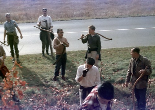
Here are a couple of images of the Trail Riders from the year before, in 1960, working on the Western trail (now #9) kindly provided by Michael MacConaill

As the work progressed the crew kept getting diverted off their intended course when they encountered already cleared work roads.
Why cut through brush when a little detour was already wide open?
Thus over two seasons the trail that was supposed to be the Alexander Road and was supposed to run between Ridge Road and Meech Lake wandered off course eventually resulting in a trail that ran perpendicular to that, between the Fortune Parkway near Fortune Lake, to The Ramparts, before hooking back to Ridge Road.
Cutting trails is tough work.
The crew involved in that tough work was headed by Ferdy Chapman and included Michael MacConaill and Doug Martin who were one day recovering their strength with Rosemary Gilliat in the original Shilly Shally; they had spent the day constructing a bridge over one of the creeks along the trail. (Note: you can see an image of Shilly Shally vintage 1960 by clicking here and scrolling to the bottom of that post)
“Bridge” might be a high complement for the corduroy assembly of logs that were actually used.
As tired workers often do they commiserated on how hard they had to work.
1961 was four years after the release of the blockbuster film Bridge on the River Kwai which had won seven Academy Awards.
The film depicts prisoners of war being forced by their Japanese captors to build a bridge.
Our Gatineau Park trail builders joked that they were being worked as hard as those POWs had been.
Geographically the River Kwai is in Thailand but in the movie the bridge was part of the Burma Railway construction project—Burma being north-west of Thailand—and so it seemed natural that this new trail in Gatineau Park should be called the Burma Road.
And yet today, once you’ve tucked your official NCC map into your pocket and glance up at the sign posted at the foot of Trail #3, you will notice no sign saying Burma, but instead one saying Huron.
Why is that?
In fact the Huron Trail was originally yet another trail that ran in yet another direction.
Its southern end was near the Huron lookout on the Champlain Parkway but it looped around toward the north-west—crossing the Burma Road twice as Burma looped north-east—and ended where the old McCloskey Farm had been; now the area where Trails#18, #20 and #21 come together. (Trail #18 is shown on a 1967 map to be a final spur of Huron Trail leading back to Ridge Road, however Michael MacConaill remembers this short trail as Walter’s Trail after Walter Roche).
Both Burma and Huron Trails were ski trails.
One of the things about ski trails is that they often make for pretty unattractive hiking trails when the swamps and lakes they cross change from beautiful white snow to bog and deep water.
For this reason the National Capital Commission in the 1970s undertook to encourage hiking by realigning what had been Burma to avoid the wetter spots and borrow a few drier sections from Huron Trail.
In so doing the Huron name was also borrowed and that’s why you see it on the signs. The eastern section of Trail #21 was originally where the Huron Trail ran.
But that was almost 40 years ago. Why is it that people still insist on calling Trail #3 the Burma Road?
One of the reasons is that Burma Road wasn’t just any old ski trail.
When it was first cut it was one of only very few trails reaching west of the Fortune Parkway. As such it was heavily used, including for Ottawa Ski Club racing. As old racers often become coaches and organizers for young racers word of mouth has carried Burma forward so that among many serious skiers Burma is the more familiar name.

 The cards that GuideGatineau has begun distributing to promote the website are considered to be highly environmentally responsible due to the fact that the paper used is 100% recycled and is produced using energy from biofuels plus the ink is vegetable based.
Pingback: Ottawa Ski Club Trail Riders, 1960. « greensleeves to a ground